Leveraging Drones: How 3FOP is Pioneering Smart Monitoring in Oil Palm Cultivation
November 5, 2025
Precision, scale, and timely decision-making are the three pillars of modern agriculture—and nowhere is this more evident than in the way 3FOP is using drone technology to transform oil palm plantation management.
As one of the early adopters of aerial analytics in the Indian palm oil sector, 3FOP is leading the charge in combining Agri-science with next-gen monitoring tools.
Managing thousands of hectares across multiple states comes with a unique set of challenges: inconsistent terrain, unpredictable weather, and the sheer scale of ground-level inspections. Recognizing these limitations, 3FOP began integrating drone-based solutions into its field operations to improve accuracy, efficiency, and responsiveness. The results have been transformative.
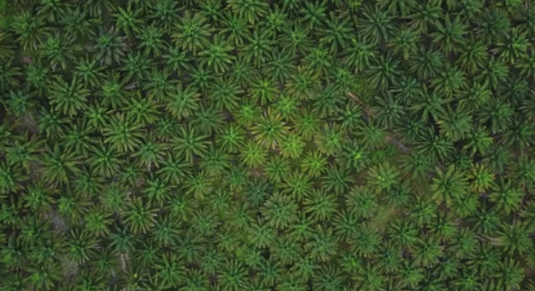
Using high-resolution imaging and intelligent sensors, 3FOP drones regularly capture critical data from above—scanning plantation blocks in minutes, not days. These aerial surveys provide accurate tree counts, identify gaps in plantation density, and help detect early signs of crop stress or pest infestation. By spotting issues from the sky before they become visible on the ground, 3FOP empowers its field teams to take proactive, data-driven action.
One of the most valuable drone applications has been in water table and irrigation monitoring. In areas where moisture distribution is uneven, drones provide real-time insights into which zones are water-deficient, helping farmers and agronomists adjust irrigation systems for optimal performance. This precision not only conserves water but also boosts crop health and yield.
Drone-based audits have also improved the transparency and accuracy of yield forecasting. By measuring canopy coverage and bunch formation across wide areas, 3FOP is able to make more reliable estimates and plan logistics like harvesting and FFB collection with greater efficiency. It’s a smarter way to sync operations across farms, clusters, and mills.
What sets 3FOP apart is not just the use of drones, but the way it has embedded aerial intelligence into its overall digital ecosystem. Data captured by drones is linked to its proprietary platforms like 3F Smart Palm, allowing field officers and managers to cross-reference aerial visuals with ground reports, soil data, and farmer feedback. The result is a fully connected view of plantation performance.
As drone technology continues to evolve, 3FOP remains committed to staying ahead—exploring advanced capabilities like NDVI imaging, AI-based disease prediction, and even autonomous surveillance for inaccessible zones. For 3FOP, drones are not just flying cameras—they are a symbol of its forward-thinking vision for scalable, sustainable palm oil production.
With this pioneering approach, 3FOP is once again setting a benchmark—not just for tech adoption, but for how Indian agriculture can leapfrog into the future using smart, integrated solutions.

6-3-569/2, 1st & 3rdFloor, Rockdale, Somajiguda,
Hyderabad, 500082
Telangana, India.

